
Given the past reactions to this blog, it may be an act of folly to take it up again but those of you who were interested in my work in 2020 and 2021 may be interested in what I am discovering now.
The initial foray into local history has blossomed into a full-blown book project which I’m tentatively calling “Between Milltown and Model City,” about the communities of Avondale Estates and Scottdale, broadly conceived, across the 20th century. In this research I am attempting broader changes in community composition, identity, and geography with remembered landscapes. In this I am working with both oral histories when I can get them and with archival collections, maps, and the US Census. I’m interested in historical patterns of everyday life as well as how those patterns are remembered today.
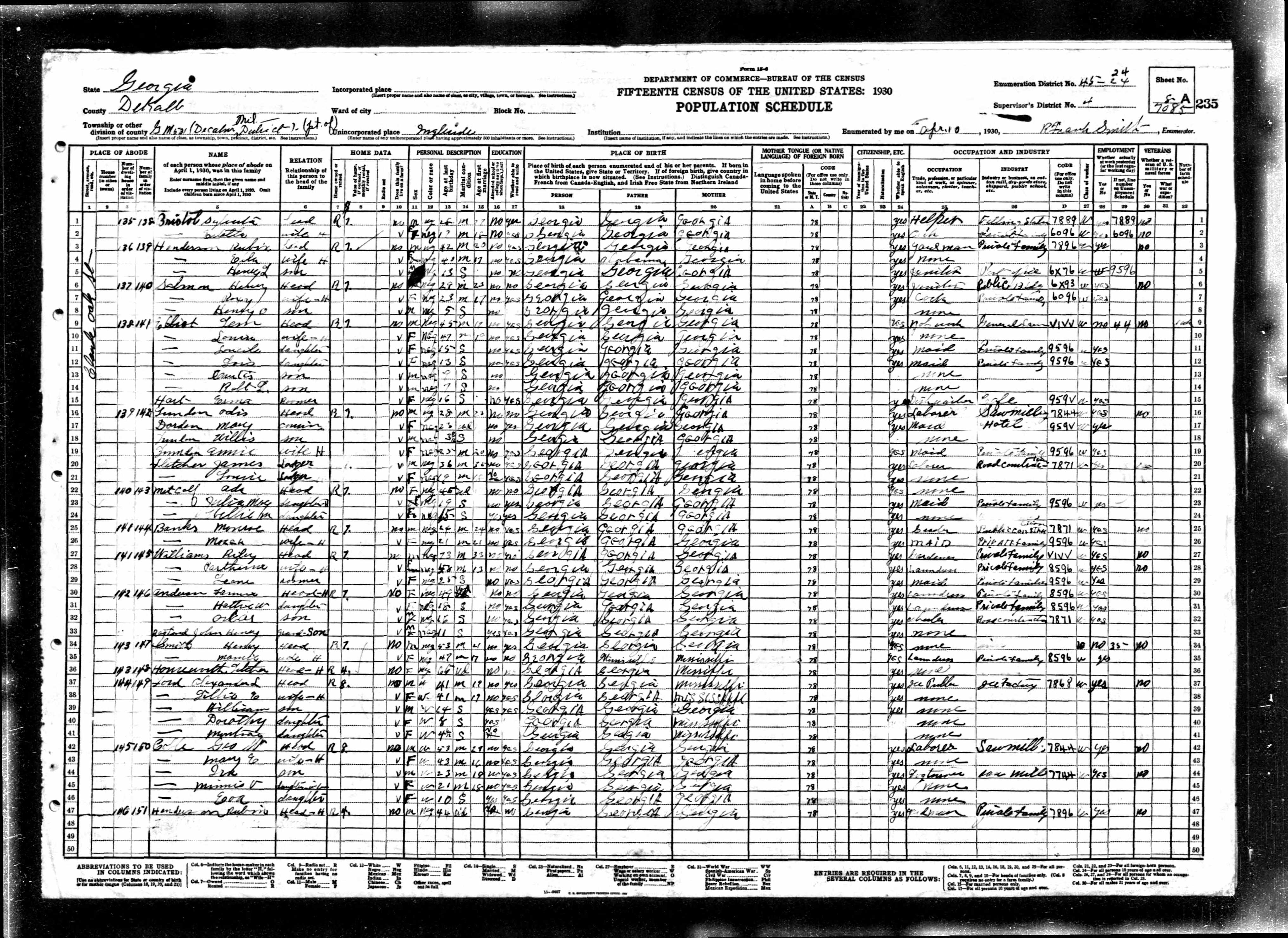
I just spent the better part of the last two weeks transcribing the 1930 Census for an area north of the intersection of Avondale Road/Covington Highway and Clarendon Avenue. This area is known at different points in time and space as Ingleside or Scottdale. Farther north it is Scottdale or Meadow Brook. I’m not entirely sure of the boundaries of Meadow Brook in Scottdale – something I must investigate with older maps since it doesn’t show up on contemporary maps. I’m wondering if this is also the area known as Eskimo Heights.
This area is fascinating to me, because it is not monolithic in its composition and changes over time, certainly more than areas like Avondale Estates and Eskimo Heights which remain pretty much homogenous. In 1930 it encompassed Oak, Maple, Washington, Locust, and Pine Streets in what is now Avondale Estates as well as the area north of Covington and South of Ponce, east of the Duck and Cordage and Scottdale Mills, both owned by the Scott family, and areas of Scottdale south and north of North Decatur Road.
In the past, I wrote about the so-called “Black side of town” in Avondale Estates, which seems officially to have only included Center and Franklin Streets. I also have heard folks refer to the area northeast of that, which was excluded from incorporation, as “the black side of town.” Since this is where segregated Black schools and churches were located, it seems apt, but it’s unclear who thought of this as part of Avondale and who did not (and there is also the distinction between Avondale and Avondale Estates, a topic for another time). One senior resident referred to the southeastern part of this area as “the other side of the tracks.” By which she meant less-affluent white residents. Historically they were not part of incorporated Avondale Estates and the houses there date to a later period. Ingleside continued to exist, at least for Census purposes, through 1930. Here Ingleside referred both to the blocks immediately to the north of Covington Highway, excluding Franklin and Center Streets which were incorporated as part of Avondale Estates. It also included Rockbridge and Indian Creek Roads as well as some part of Stone Mountain Highway (now North Clarendon). This area was a diverse mix of homeowners and renters, Black and white families. Some white-collar workers, skilled laborers, textile mill workers, and domestic servants/general laborers with a few farming families.
I’ve been combing through blocks and a few patterns suggest themselves:
1. Unlike Avondale Estates where every house has a house number, a fixed address, outside of the incorporated city no structures have house numbers, at least in the Census. I am hoping plat maps yield more information but this will make it challenging to generate maps. This also suggests that the infrastructure of this area is undeveloped at this time, which corresponds to other accounts. One wonders how the mail was delivered, or if the census worker didn’t see fit to record identifiers for these houses.
2. This area is mixed-race in 1930, with some qualifications. In what is now Avondale Estates, the small streets south of the Cordage Mill were home to an array of households, most of them working class. All of Pine Street was occupied by white cotton mill workers. On Oak Street homes were rented by both Black and White families. Most Black families on this street were servants or laborers, most white families. Washington Street was all white and included a few homeowners such as butcher John Head and rental agent George Thomason. Locust Street was diverse and its residents included Black families like the Cox family (Marvin Cox farmer (34) and wife Hathie, laundress (20) living with his mother and sister Be, both laundresses; brothers Willy and Eugene, construction laborers; and young nephew Clifford), and the Thompson household, which included gravedigger Claude Thompson (36) wife Josie, three daughters ranging in age from 18 to 3 months and two sons. Other families on this street were white. Only one, John Brinkley, owned his home. He was a telegraph operator for the steam railway whose daughter and her family of two children also lived with him. His son-in-law was a conductor for the Pullman Co. It’s unclear what the relationship of these homes was to each other, whether they were all on the main street or if there were alleyways or dependent structures. Many of the structures were rented homes.
3. Households looked a little different in Scottdale/Ingleside. While Avondale Estates was dominated by nuclear families, in Ingleside and Scottdale, households were more diverse, including extended families, adopted children, adult children (married and single), adult siblings, and boarders. A noticeable percentage of households, both white and Black, were headed by widows living with their children, siblings, or renting rooms. Very few of the white household heads owned their own homes. Those that did tended to be skilled laborers, retail workers or clerks, managers, or shop owners.
4. This wasn’t just the Black side of town. The predominance of white working-class families in this area in 1930 suggests that class was as salient to the identity of Avondale Estates as race was. Yes, the properties in Avondale Estates were restricted by racial covenants. Class would have been maintained through property values. The value of homes in Ingleside and Scottdale range from $500 – $2000 dollars on average while the minimum starting price for homes in Avondale in the mid 1920s was $6000. Homeownership seems to have been the exception, not the norm, in Ingleside. The majority of white property owners were located on Stone Mountain Road or Rockbridge Road. The majority of Black property owners were located in the Meadow Brook section of Scottdale. Most of the Black families that lived on the same street as white households were renters.
5. Occupations in this area were closely tied to the local community and industries. Many white families worked in some capacity at one of the two cotton mills. Others worked for the railroad or in housing and road construction. I suspect that these jobs were tied to development and growth in this area. A large number of the Black households in this area were sustained by some kind of domestic service: chauffeurs, cooks, a few butlers, lots of maids and laundresses — the two most common occupations for wives in Black households during this period — usually for a “private family.” Others worked at local farms, as truck drivers and in service jobs at local institutions like “university” or “hospital.” This suggests that many of the Black families living in Ingleside or Scottdale during this period worked for families in Avondale Estates and possibly Decatur.
So race clearly still matters. A majority of the Black households in this period were dual income, with both husband and wife working and most Black residents were confined to a specific range of occupations. Most who lived in proximity to white households were renters, with Black homeowners concentrated together in a northeastern section of Scottdale (Meadow Brook/Eskimo Heights). Many of these families worked for nearby white entities within a larger segregated landscape. This landscape was not uniformly black/white in 1930, but it was segmented by race and class.
Thuse the “Black side of town” as a vernacular distinction was salient in this period, but it does not capture the full picture of community in the area bordering Avondale Estates in this period. There are clearly class dimensions to the local geography and sense of place. It will be interesting to see how these patterns evolve over time in 1940 and 1950, as well as what additional insight plat maps and other sources will give me into the relationship between these different households in terms of where they were located on the street and in what structures.
As always, please take what is above as work-in-progress. My conclusions are always tentative and can change as the research reveals itself.

